
What you'll need to know...
KEY CONCEPT - How physical processes influence drainage basin systems and landforms
The drainage basin as an open system with inputs (precipitation of varying type and intensity), outputs (evaporation and transpiration), flows (infiltration, throughflow, overland flow and base flow) and stores (including vegetation, soil, aquifers and the cryosphere)
River discharge and its relationship to stream flow, channel characteristics and hydraulic radius
River processes of erosion, transportation and deposition and spatial and temporal factors influencing their operation, including channel characteristics and seasonality
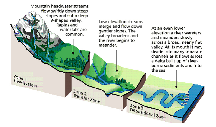
The formation of typical river land forms, including waterfalls, floodplains, meanders, levees and deltas
The drainage basin as an open system with inputs (precipitation of varying type and intensity), outputs (evaporation and transpiration), flows (infiltration, throughflow, overland flow and base flow) and stores (including vegetation, soil, aquifers and the cryosphere)
River discharge and its relationship to stream flow, channel characteristics and hydraulic radius
River processes of erosion, transportation and deposition and spatial and temporal factors influencing their operation, including channel characteristics and seasonality
The formation of typical river land forms, including waterfalls, floodplains, meanders, levees and deltas
Drainage Basins...
|
Objective: To analyse the drainage basin as an open system with inputs (precipitation of varying type and intensity), outputs (evaporation and transpiration), flows (infiltration, throughflow, overland flow and base flow) and stores (including vegetation, soil, aquifers and the cryosphere)
Starter: Watch the video to the right hand side and make notes on the following: i. What is a watershed/drainage basin? ii. What are the main functions of a watershed/drainage basin? iii.How can human action can influence the functioning of the system? Task 1 - Study the 'Systems Approach' embedded presentation from geographyalltheway carefully. Make a copy of the two diagrams showing open and closed systems. Label the open system diagram with some of the features you noted during the starter activity. Further higher level definitions of systems can be found here. Task 2 - Study the definitions below carefully and then copy and paste them into the correct column in the worksheet below. This site may help you (but try not to use it unless you are stuck!) |
|
Percolation: When water travels from unsaturated ground into saturated ground.
Interception: When an object (building, tree) stops precipitation reaching the ground beneath.
Transpiration: Liquid water evaporating from vegetation.
River discharge: Eventually most rivers enter the sea and discharge the river's flow into the sea.
Groundwater flow: The movement of water through saturated ground.
Channel flow: Water that is travelling in rivers or streams.
Surface run-off (overland flow): When water travels across the surface of the earth
Stem flow: When intercepted water then travels down the branches and trunks of vegetation.
Evaporation: Liquid water from surface stores and rivers turning into water vapour (gas).
Surface storage: Any water that is held on the surface of the earth e.g. lake or pond. Some surface stores like puddles may only be temporary.
Infiltration: When water travels from the surface of the earth into the ground beneath.
Groundwater storage: Water that is stored in saturated ground.
Throughflow: The movement of water through unsaturated ground.
Canopy drip: Intercepted water dripping off vegetation onto the ground.
Soil-moisture storage: Water that is stored below the surface in unsaturated ground.
Precipitation: Any moisture that falls from the sky e.g. rain or snow.
What is the Cryosphere?
From Wikipedia. The cryosphere is those portions of Earth's surface where water is in solid form, including sea ice, lake ice, river ice, snow cover, glaciers, ice caps, ice sheets, and frozen ground (which includes permafrost). Thus, there is a wide overlap with the hydrosphere. The cryosphere is an integral part of the global climate system with important linkages and feedbacks generated through its influence on surface energy and moisture fluxes, clouds, precipitation, hydrology, atmospheric and oceanic circulation. Through these feedback processes, the cryosphere plays a significant role in the global climate and in climate model response to global changes
From Wikipedia. The cryosphere is those portions of Earth's surface where water is in solid form, including sea ice, lake ice, river ice, snow cover, glaciers, ice caps, ice sheets, and frozen ground (which includes permafrost). Thus, there is a wide overlap with the hydrosphere. The cryosphere is an integral part of the global climate system with important linkages and feedbacks generated through its influence on surface energy and moisture fluxes, clouds, precipitation, hydrology, atmospheric and oceanic circulation. Through these feedback processes, the cryosphere plays a significant role in the global climate and in climate model response to global changes
Task 3a - Click here to access a task to complete on the GATW site (subscription required). Complete the 'Drainage basin - an open system' annotation task.
Task 3b - Add additional 'sub' boxes and a suitable colour code to show the effects of the cryoshpere on the open systems diagram you have just completed. Ensure that you read the information above carefully first to identify where in the system, water can be stored as ice.
Now ensure that Task 3 & 4 elements are kept together (electronically or in your folder).
All rivers receive a water supply and the area of land this comes from is known as a drainage basin. The boundaries of the basin are known as the watershed and will usually be marked by areas of higher land.
River Form & Velocity...
|
Objective: Define stream discharge. Examine its relationship to stream flow, channel characteristics and hydraulic radius.
I use Integrated Approach (Waugh) for this section of the work page 68-70. Starter: Watch the video from 1:02 to the end and take notes on the worksheet from the sections on velocity, slope and discharge. Watch the information on channel shape too, we'll be covering that next. Now turn to page 68 in Waugh. Task 1 a - Outline the role played by friction in the flow of water b - Define the two types of water flow. c - Copy figure 3.15 (laminar flow - link) into your work book and label appropriately. d - What is the relationship between velocity and turbulence? e - Copy figure 3.15 (turbulent flow - link) into your work book and label appropriately. f - Outline and sketch the three main influences on river velocity. This will include diagrams 3.16 (link), 3.17 (link), 3.19 & 3.20. Task 2 - Copy & Complete the following sentences, deleting as appropriate •A river in a deep, broad channel, often with a gentle gradient and small bedload, will have a greater/lesser velocity than a river in a shallow, narrow, rock filled channel – even if the gradient of the latter is steeper. •The velocity of the river increases/decreases as it nears the sea •The velocity increases/decreases as the depth, width and discharge of a river all increase. •As the roughness increases/decreases, so does turbulance and the ability of a river to pick up and transport sediment. |
Key Words
Bed: The bottom of the river channel Bank: The sides of the river channel. Channel: The confines of the river, encompassing the bed and two banks. Wetted Perimeter: The total length of the bed and the banks in contact with the river. Cross-sectional area: The width of the river multiplied by the depth of the river. Because the depth of the river will vary across its width, an average depth reading is normally taken. The cross sectional area is normally given in m2. Velocity: This is the speed that the water in a river is travelling at. The unit of measurement is normally metres a second (m/s). River velocity can be measured using a flowmeter (pictured right), or more commonly by timing a floating object over a set distance (pictured left). Velocity is then calculated by dividing the time (seconds) by the distance (metres). Discharge: This is the amount of water in a river at a given point. Discharge is normally measured in cumecs (cubic metres a second). It is calculated by multiplying the cross-sectional area by the velocity. As you move from the source to the mouth, both the discharge and velocity of a river increases. |
Modelling this relationship...
|
Homework
Make a copy of the Bradshaw Model as shown in the presentation to the left hand side. Mount it in the centre of a piece of A3 paper. Annotate each of the factors to show why they increase or decrease as you move from the upper to lower course of the river. Exam question Briefly examine the relationship between stream discharge and channel shape. (6) |
River processes of erosion, transportation and deposition...
|
Objective: To examine the river processes of erosion, transportation and deposition and spatial and temporal factors influencing their operation, including channel characteristics and seasonality
Generally, if you have preceded IB Geography with IGCSE or MYP, you will have some experience of the processes of erosion, transportation and deposition. You will know that each of the three processes are intrinsically linked and that major land forms are often a result of two or more of these processes that shape our landscapes. Reminder Task: Complete the reminder worksheet below, using the embedded Slideshare from geographyalltheway.com to the right as your main source of information. So, now we had reminded ourselves of the basics, we must now study briefly how spatial and temporal factors influence their operation. To do this, we will again be revisiting channel characteristics and seasonality.
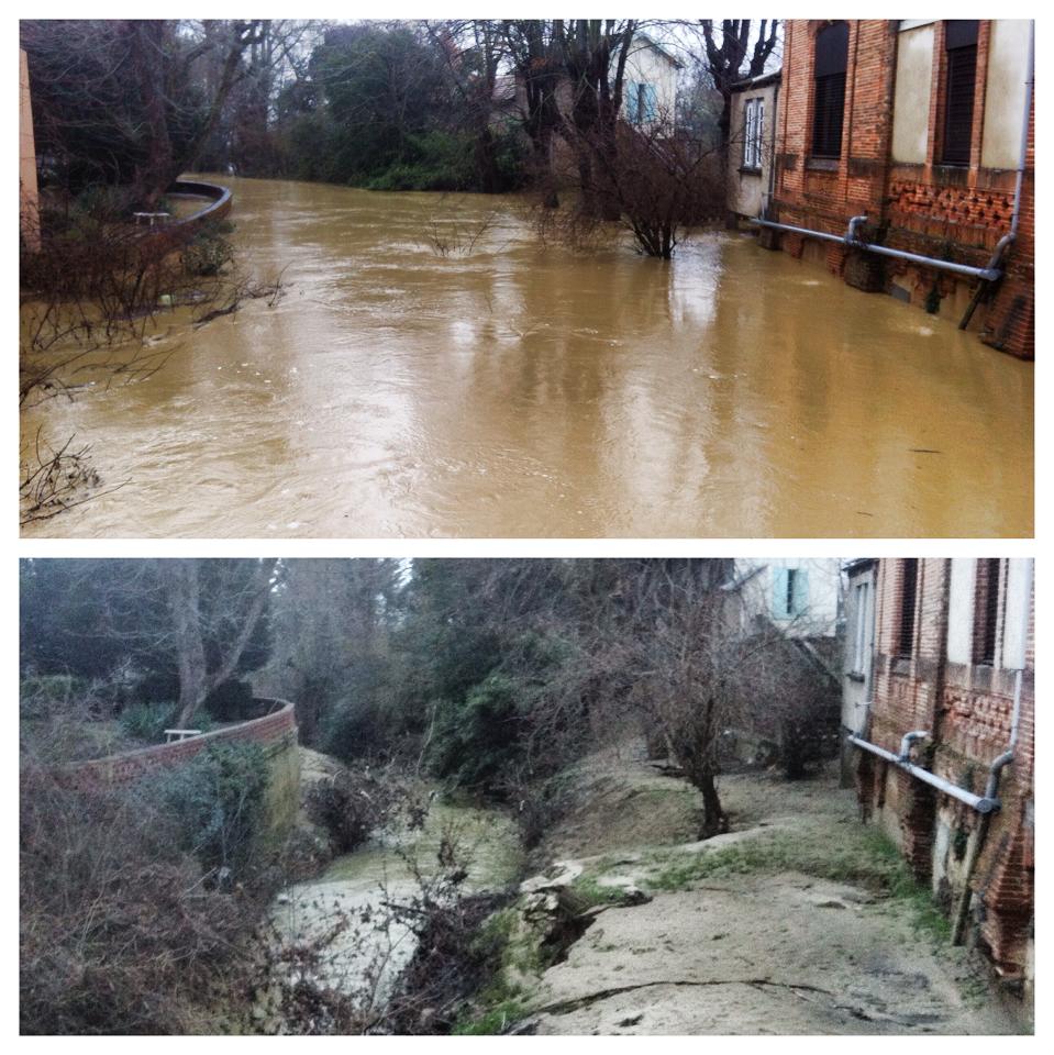
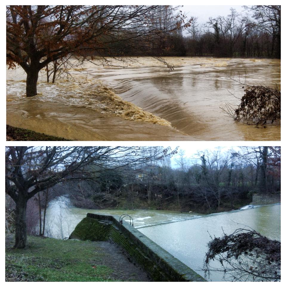
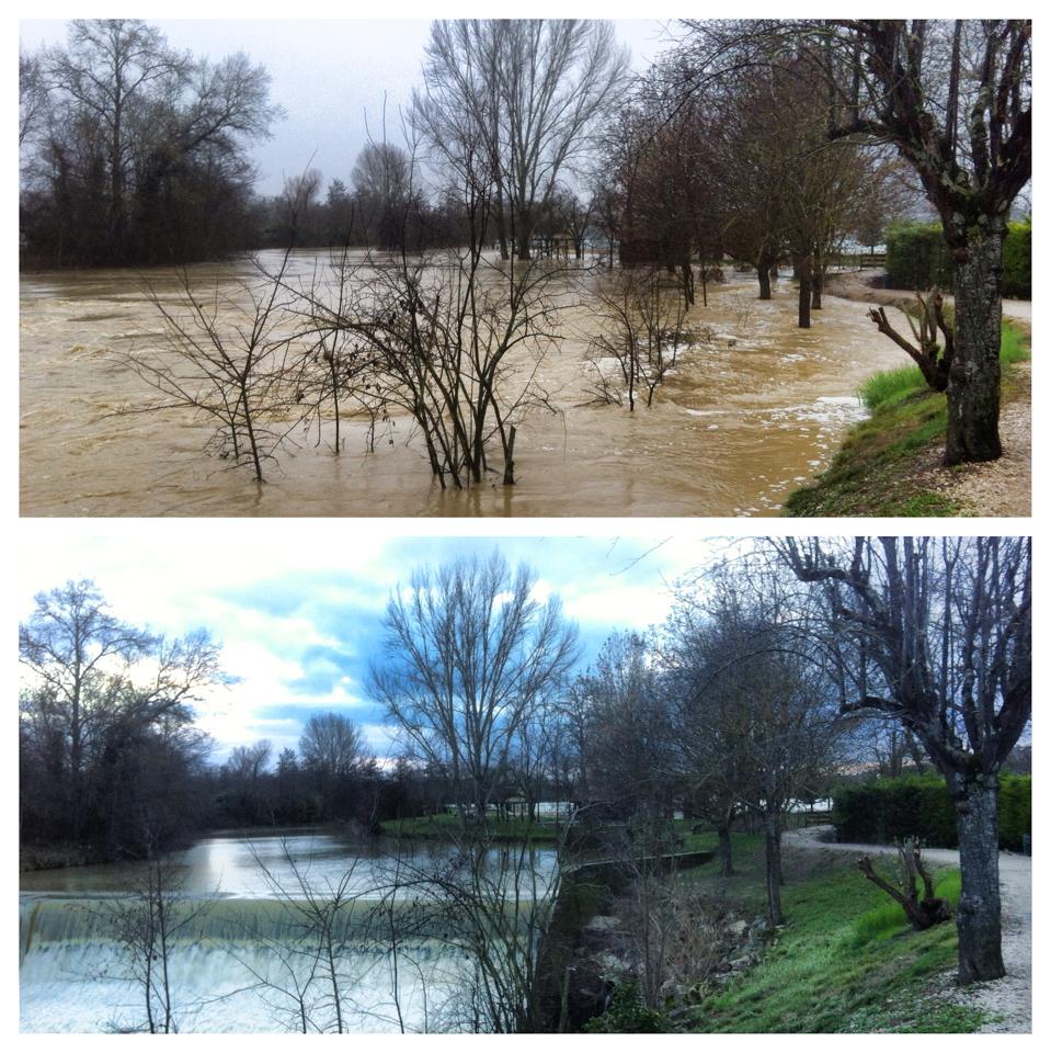
Task 1 - Complete the worksheet embedded below. The images below will help you to complete the section on seasonality and its effects on fluvial processes
|
Source: riverrestoration.wikispaces.com
|
|
|
|
|
|
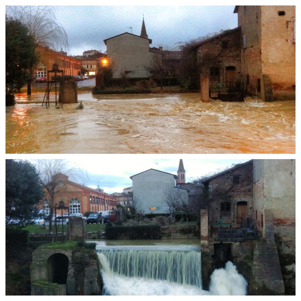
The images above were taken in the town of Samatan in the Midi Pyrenees region of France in February of 2014. The flooding event followed a period of heavy precipitation on an already saturated surface. Heightened overland flow due to ploughing of surrounding farm land and heavy clay characteristics of the soil were also contributing factors.
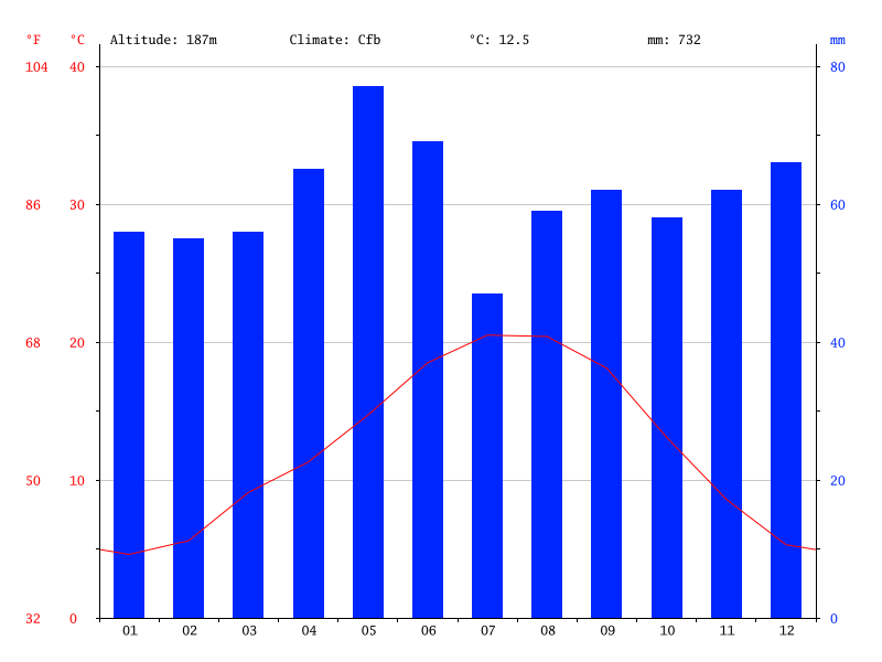
Click on the images to see an enlarged version. The top photo was taken during the flood event and the bottom photo was taken four days later when the river had returned to its pre-flood level. To the right is a climate graph for the town of Samatan showing annual precipitation and temperature range. Use this information to complete the activity on the second side of the worksheet. |
|
The formation of typical river land forms...
|
Objective: To explain stream channel processes and explain the resultant land forms found on floodplains.
Research Task - IST students will be familiar with Elliot Brown from their IGCSE work. Good news is that you've got some more of him to come! Video to the right is your starting point. He's looking mightily cool in those shades! You are going to split into teams. Each team will research one of the following: Team 1. V-Shaped Valleys Team 2 - Waterfalls Team 3. Floodplains, levées, Team 4 -Deltas Team 5. Meanders, oxbow lakes & point bars Task 1 - You are going to create a three strip cartoon about your allocated features under the headings above.
Excellent source of information here from the British Geographer. You might also want to approach this piece of work by creating a revision video work using the technique shown to the right by some IST Geographers back in 2014. Paper 1 - Exam Question. Fluvial land forms can only be classified as either erosional, depositional or transportational. Critically examine this statement. (10) You are going to write this up as a group effort (use the framework sheet below right) Watch the five videos above. Making notes on the processes of formation, use at least four examples of the features to attempt to answer the question above. Don't forget to use the IB Essay Planning Tool. |
|