
What you need to know...
KEY CONCEPT - How geophysical systems generate hazard risks for different places
The distribution of geophysical hazards (earthquakes, volcanoes, mass movements)
The relevance of hazard magnitude and frequency/recurrence for risk management
Geophysical hazard risk as a product of economic factors (levels of development and technology), social factors (education, gender), demographic factors (population density and structure) and political factors (governance)
Geographic factors affecting geophysical hazard event impacts, including rural/urban location, time of day and degree of isolation
Distribution of earthquakes...
Starter - Watch the animated video below that displays all recorded earthquakes between the year 2000 - 2015. Watch carefully for the 2004 Indonesian earthquake that caused the devastating tsunami as well as the Japanese quake and tsunami of 2011.
Task 1 - Complete Tasks 1a - 1f on the worksheet above.
Task 2 - Spend four minutes watching the second video below. What is a subduction zone and how do they cause earthquake activity?
|
|
|
|
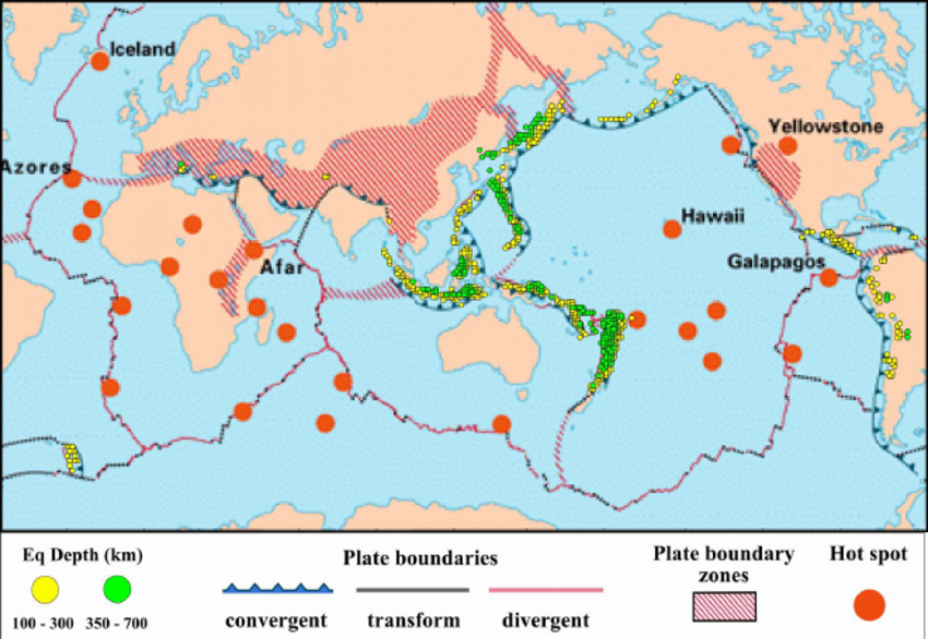
Task 3 - Study the map to the right. a. Which type of boundary is associated with subduction zone earthquakes? b. Describe the spatial distribution of the potentially damaging shallow (100-300km) earthquakes globally. c. Using this image, describe the frequency and severity of earthquakes in the Japanese subduction zone according to depth. d. Using the image from task 3c, identify what additional tectonic hazard is produced as the Oceanic crust descends into the Asthenospheric Mantle? Check out the liquefaction video to the right hand side. His attempts to shake the ground represent the earthquake shock waves (S) that loosen the structure of surface materials. Indonesian Earthquake & Liquefaction (2018) Task 4 - A large earthquake triggered a mass movement event, know as liquefaction in Indonesia. Watch this video and note how earthquake events can be linked to mass movement events. |
|
Distribution of volcanoes...
|
Starter: What are volcanoes? Watch the section of the video from to the right (14.40 - 19.45). Take notes.
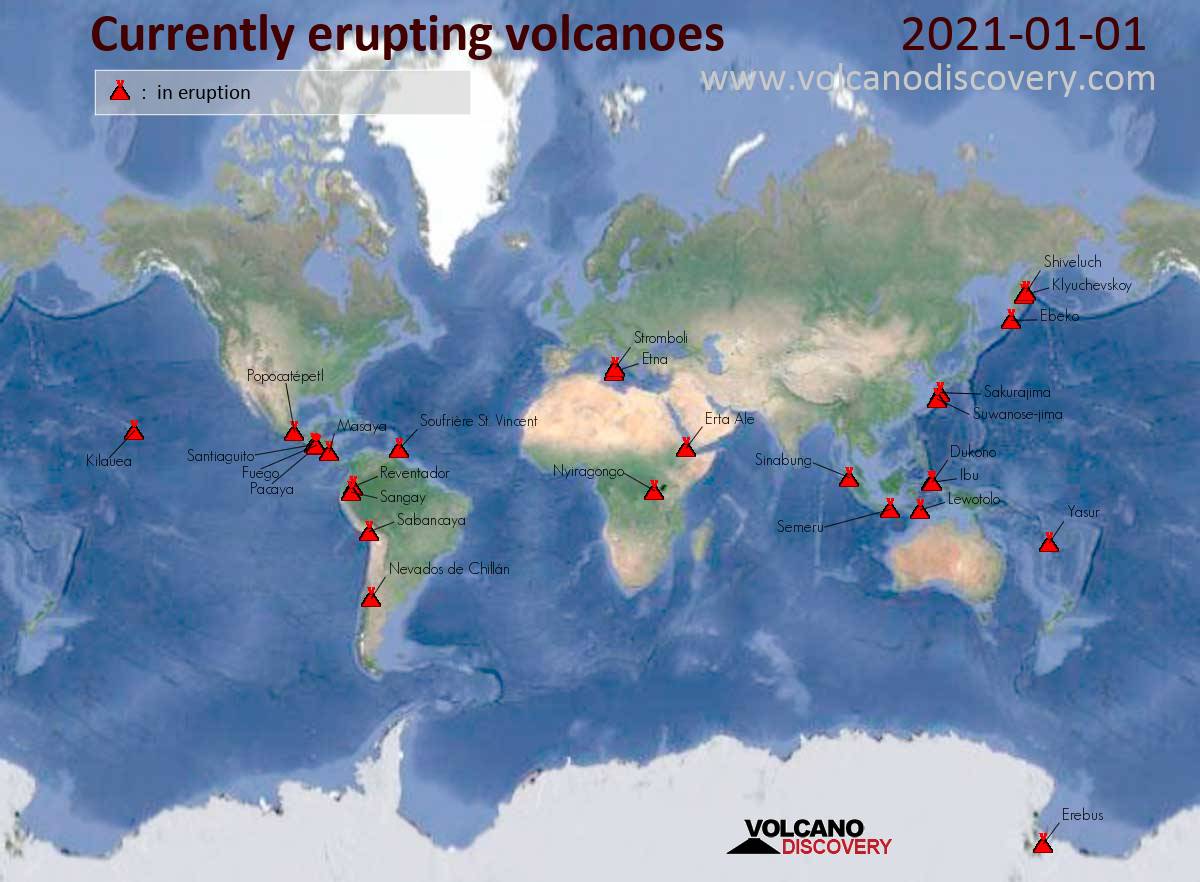
Task 1 - Click on this link to view a historical record of all volcanic eruptions over the last 10,000 years. a. Describe the spatial distribution of volcanoes around the planet including the areas of highest concentration. b. Compare the map from the previous task with the plate boundary map in the 'Earthquakes' section above. Which type of plate boundary is most associated with volcanic activity? c. Using this image, describe where the most dangerous volcanic areas are (in terms of human deaths) and offer at least one explanation for the high death rate in a certain region. Extra - Using this site (which will show a map similar to the map on the right), check out the current distribution of active volcanoes globally. How far are you from the closest active volcano? d. Now go back to the first video and watch from 19.45 to 21.38 to find out about why Hawaii is volcanic despite being thousands of KM from a plate boundary. Take notes. *Clearly, in the examination, you aren't going to use the pineapple analogy, so please find a suitable image of volcanic hotspot formation to compliment your notes above. |
|
|
e. Which major mountain ranges also have volcanic activity? What are the links between volcanic activity and the formation of 'fold mountains'?.
The Indonesian Volcanic Eruption & Tsunami 2018 In late December 2018, the explosive eruption of Anak Krakatau (Indonesia) caused a volcanic landslide that generated a deadly tsunami. This is an example of how a volcanic eruption can be the cause of devastating mass movement. This will be your case study later in the unit. Check out the video to the right to see how such eruptions can cause a tsunami. |
|
Distribution of mass movements...
|
Starter: Watch the first video to the right and note the links between the eruption and subsequent potential landslide on La Palma. This links a number of hazards that you have already studied.
Task 1 - Now watch the second NASA video to the right. Make a note of: 1. Seasonal landslide events linking to well-known precipitation led events. 2. The link between landslide events and plate tectonic movements (particularly those involving the formation of fold mountains). Task 2 - Study the landslide fatality map below. Comment on the relationship between plate boundaries, mass movements, monsoon events and population distribution as contributing factors to death rates. |
|

Managing Hazard Risk...
In this section, we will briefly look at the relevance of hazard magnitude and frequency/recurrence for risk management, that is, how can we use the past to try to predict the future.
The resource wall below lists the following case studies.
1. Earthquake
2. Volcano
3. Landslide
Take notes on all three areas above by using the videos below as your starting point as well as other research. The objective is to answer the following 6 mark question:
Distinguish between the strategies used to manage the risks of geophysical hazards (6).
|
|
|
|
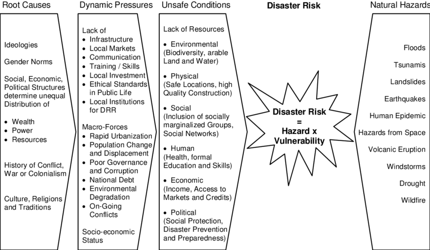
Risk as a product of social, economic, demographic & political factors...
Task 1 - Complete a summary activity / AI instructional activity focusing on social, economic, demographic and political factors that cause increased risk, in the three different hazards that we have looked at.
The teacher will need to lead the start of this activity.
You should use the image below as well as this article from the Population Reference Bureau (PRB) to help you to fill in your seven branches.
The teacher will need to lead the start of this activity.
You should use the image below as well as this article from the Population Reference Bureau (PRB) to help you to fill in your seven branches.
Source - here
Geographic factors affecting geophysical hazard event impacts
This section will be covered as part of the six case studies in the next section of work and linked to these individual hazard events. These will relate the following factors to each case study:
- rural/urban location
- time of day
- degree of isolation