The River Aussonnelle - France
IB DP Geography - How do the fluvial characteristics of a river change with distance from the source?
IGCSE Geography - How does the River Aussonnelle change downstream?
|
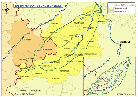
The Aussonnelle is a river in the south of France that flows in the Haute Garonne département in the region of Occitanie. It is a tributary of the more famous River Garonne.
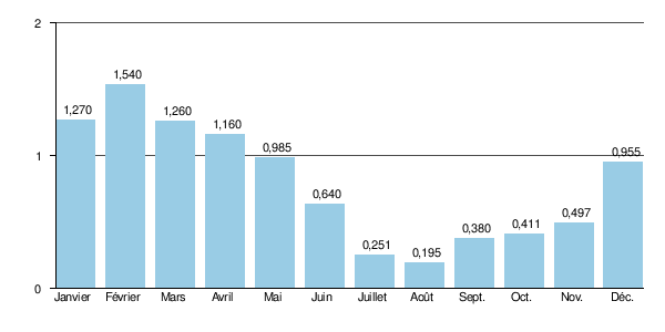
At nearly 43km long, the Aussonnelle has its source close to the village of Saint-Thomas in Haute Garonne right on the border with the Gers département and enters the River Garonne on its left bank between the towns of Seilh and Gagnac-sur-Garonne. The source of the river is at an altitude of almost 300 metres above sea level and at the point where it joins the Garonne, the altitude is 117 metres above sea level. In total, the Aussonnelle drainage basin covers approximately 190km2 which is mostly situated in Haute Garonne with a small area in the Gers too. The following rivers are tributaries of the Aussonnelle: Le Guignorieu : 5,1 km Le ruisseau des Crabères : 7,7 km Le Vidaillon : 4,6 km Le Courbet : 10,1 km Le ruisseau du Rouchet : 5,5 km Le ruisseau du Gajea-Panariol : 14,3 km Le Barnefond : 5,5 km Task 1 - Describe & explain the average monthly discharge of the river using the graph to the right. |
|
Aussonnelle - Study Sampling Locations 1 - 6
Below, you will see a 10 second video filmed at each location and the French IGN map of the study site showing topography (contours) and land use. You will need to use both of these pieces of information together with any photos you take in each location in the completion of this work.
|
|
|
Collecting Your Data - Sampling
As you have seen from the map above, you will be completing your study at 6 different locations along the River Aussonnelle.
We will be gathering data by using sampling. In our fieldwork, sampling is going to be the process of collecting data from some sites in order to obtain a perspective on the river. You can find out more about sampling by clicking on this link.
Task 2 - Watch both of the videos below. (Note: The One Show is a popular evening television programme in the UK).
i. How were the data collection sites chosen?
ii. Is there a better way of choosing data collection sites?
iii. What is sampling?
|
|
|
Collecting Your Data - Methodology
All IGCSE & IBDP students will be collecting data together. The more data you collect, the better. You do not have to use all the data collected during the write-up of your IA and coursework.
You will be collecting data on the following variables:
Occupied Channel Width
Bankfull Width
Wetted Perimeter
Gradient
Cross sectional area / profile
Velocity
Bedload size
Bedload shape
Task 3 - Define each of the variables above and suggest how you might go about measuring each one.
Task 4 - Study the map at the top of this page and the individual study area maps (IGN) above.
i. Describe how the topography of the drainage basin impacts upon the fluvial characteristics of the River Aussonnelle.
ii. Using the same maps as the previous task, explain how the landuse may impact the fluvial characteristics
Task 5 - IB DP only - Click here to access background reading on river processes and how they change along the long profile. Highlight the key changes that occur in velocity, gradient & load.
Data Collection Booklets...
A massive thanks should go to Richard Allaway and Ellena Mart over at the International School of Geneva for the use of their data collection booklet and for general inspiration. A further thanks goes to Veryan Blake at St George's School for her help and support too. Geography teachers are the best!


